2014

Tuolumne Meadows Virtual Hike

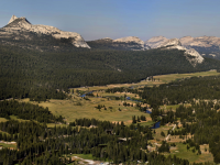
Tuolumne Meadows, located at 8500 ft in Yosemite National Park, is an iconic example of a high-elevation Sierra Nevada meadow system. Part of the headwaters of the Tuolumne River watershed, the broad U-shaped valley is surrounded by granitic domes and peaks shaped by past glacial processes. The Tuolumne River winds through the meadow complex, fed by snowmelt from permanent snowfields on Mt. Dana and Mt. Lyell. This virtual hike takes you along the Tuolumne River through the main Tuolumne Meadow complex. The hike begins on top of Lembert Dome, with a view overlooking the meadow complex. From there you can jump down to the hike along the river, which starts at stop 1 upstream of the Highway 120 and extends for approximately 3 miles downstream to the base of the meadow at stop 49. An interpretive trail with informative videos that are based on the real interpretive trail signs located in the park can be found between stops 10 and 24.

California Virtual Water Tour

There is no other state where water and economic development is so tight than in California. Since the gold rush, water has been the engine that has promoted economic and social development in the state. Water is still a precious resource in California; however, by nature, the distribution of water and ecosystems across the state are highly variable, from glaciers in Mount Shasta and high snowfall in Northern California to almost no precipitation in the Mojave desert in Southern California. Furthermore, water infrastructure conveys water across different regions, connecting the resources and issues across the state. This Virtual Tour will provide short presentations or Stops on the physical aspects and current issues for 16 regions as it relates to water in California. Click on the links below to view the presentations.

Climate Change Threats to California Inland Fishes

Today, nearly 50 percent of California’s native freshwater fishes face a high risk of extinction. Add the stress of climate warming, and the projected extinction rate rises to 83 percent within the next 100 years if present trends continue. Much of the unique California fish fauna will vanish and cede their habitats to carp, bass and other alien fishes. More effective conservation efforts would come from a better understanding of the biology and vulnerability of native fishes.

California Water Policy Seminar Series: Reconciling Ecosystem & Economy

This series of nine presentations was open to the public and available for academic credit to ECI 296/CRN 60166. An extended graduate seminar included small group discussions with speakers following the public talk and a term paper. Seminar leaders: Jay Lund, director of the Center for Watershed Sciences and Richard Frank, director of the California Environmental Law & Policy Center at the UC Davis School of Law.

Grand Canyon 2014

This 3 unit graduate seminar will 1) familiarize student participants with the geology, ecology and management issues associated with the Grand Canyon and Colorado River in the context of global change, and 2) encourage students to become class “experts” in some critical issue or concept relevant to river science in the context of global change.

Tuolumne River 2014

An extension of previous ecogeomorphology classes, this class is a field-based multidisciplinary study of the ecology, geomorphology and management of rivers in the Sierra Nevada mountains of California, with a focus on the Tuolumne River watershed. Open to upper-division undergraduate students, the course brings together students from a range of biological and physical sciences and engineering backgrounds to address conservation and management issues in California watersheds.