Based on the presentation “Role of volcanism in the Grand Canyon” by Catt Wesoloski, February 22, 2017
Volcanoes are one of the most powerful and dramatic land-shaping forces on Earth. Formed when molten rock and gases escape through cracks in the Earth’s crust, volcanoes can create entire mountains in the geological blink of an eye. In contrast, the primary force creating the Grand Canyon was the gradual process of the Colorado River eroding through layer upon layer of rock over millions of years. Yet this long, slow process of canyon formation by water has been punctuated by fiery volcanic activity, and volcanoes have made their mark on the Grand Canyon.
The Uinkaret Volcanic Field
There were actually several volcanically active areas on the Colorado Plateau near the Grand Canyon, explains Catt Wesoloski, a graduate student at UC Davis. However, only one of these volcanic fields was both close enough to the canyon and active recently enough that it had a direct effect on shaping the Grand Canyon as we know it today. This volcanic area, known as the Uinkaret volcanic field, lies on the north side of the western Grand Canyon in Arizona, and covers an expanse of about 1,500 square kilometers. The oldest volcanic rocks in the Uinkaret volcanic field date from about 3.6 million years ago, a few million years into the formation of the canyon. After an initial eruptive period, the field became relatively quiet for over 2.5 million years, but picked up again around 700 thousand years ago. Activity peaked between about 500- 600 thousand years ago, but the most recent eruption is only 1,000 years old; the area could still be volcanically active.
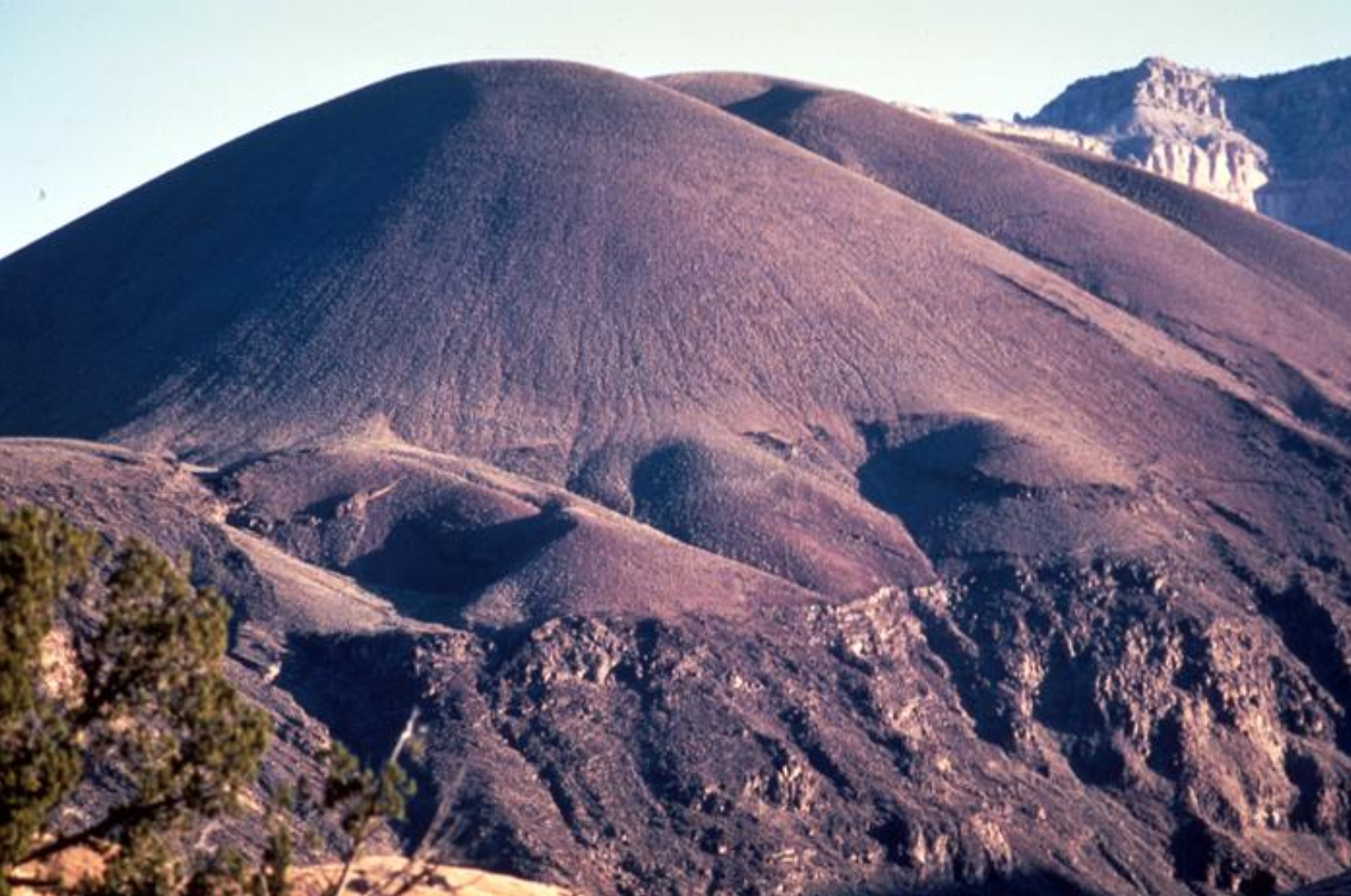
The many eruptions have left the Uinkaret volcanic field dotted with volcanic cinder cones— mounds of rock fragments formed when molten rock erupting high into the air from a volcanic vent cools into small pieces, called pyroclasts, before hitting the ground. The Uinkaret cinder cones are formed of basalt, just like the rocks in Hawaii, says Wesoloski. Vulcan’s Throne (Figure 1), a large cinder cone on the rim of the Grand Canyon, is likely the most famous of these formations, but the Uinkaret volcanic field has a whopping 213 individual cinder cones.
Lava Dams
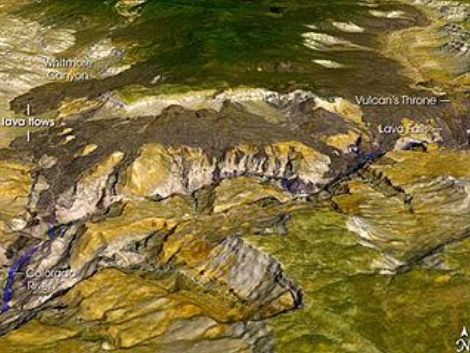
A more direct impact of volcanism on the Grand Canyon occurred when fire met water in the canyon depths. Given the large controversy surrounding the construction and maintenance of the Glen Canyon Dam, which was erected upstream of the Grand Canyon in the 1960s, it may be surprising to learn that humans are not the first to dam the waters of the Colorado River— volcanoes have actually dammed the river at least 13 times. Lava flowing into the river (Figure 2) created these massive natural dams, which ranged from 60 to 700 m tall; for comparison, Glen Canyon Dam stands at around 215 m.
The structure and longevity of these dams is still debated, says Wesoloski, and the degree to which the dams formed complete barriers for the river’s flow is under question. However, at least some dams likely impounded large amounts of water, similar to the formation of Lake Powell behind Glen Canyon Dam, as we do have evidence of the outwash when these dams eventually succumbed to the power of the river and failed catastrophically. Each dam was likely formed and destroyed within the span of about 10,000-20,000 years. This is a relatively short duration on a geological time scale, but considering the significant ecological changes that have occurred in the mere half-century since the Glen Canyon Dam was erected, the lava dams likely had a large impact on the Colorado River ecosystem. Though the dams themselves are gone, they are still important for visitors to the Grand Canyon today because, as Wesoloski notes, their remnants create some “insanely wicked” rapids.
Volcanoes Help Us Understand the Grand Canyon
In addition to shaping the Grand Canyon landscape and visitor experience, volcanic rocks can be very helpful for scientists trying to understand how the canyon was formed, and what processes are still at work today. Wesoloski explains that scientists can date volcanic rocks along the canyon, and then measure the vertical distance from these rocks to the base of the river to calculate the canyon’s incision rate, or the rate at with the Colorado River has cut down through the rock over time. The incision rate is important because it affects how much sediment the river transports, an important consideration for river biota, and also tells us about the river’s gradient, or steepness, which affects the shape of the canyon and the river.
Scientists can similarly use the volcanic rocks to estimate the slip rate for tectonic faults that border the Uinkaret volcanic field. Scientists date rocks on either side of the fault and measure the displacement between rocks of the same age to calculate the rate at which the two sides of the fault are moving relative to one another. Why do these slip rates matter? Because the faults are still active, says Wesoloski, and slip rates can help us characterize the frequency and magnitude of earthquakes. Faults with faster slip rates tend to produce more frequent and larger earthquakes, which is crucial for assessing the seismic hazard in an area.
While the Colorado River may still be the star of the show in the Grand Canyon’s formation, volcanoes have helped make the canyon what it is today, and have also helped us understand its history.
Thanks to Catt Wesoloski for her presentation and additional input to inform this post.
Additional references:
Crow, R., K. E. Karlstrom, W. McIntosh, L. Peters, and N. Dunbar. 2008. History of Quaternary volcanism and lava dams in western Grand Canyon based on lidar analysis, (40)Ar/(39)Ar dating, and field studies: Implications for flow stratigraphy, timing of volcanic events, and lava dams. Geosphere 4:183–206.
Oregon State University. 2017. Volcano World. http://volcano.oregonstate.edu/.
United States Geological Survey. 2014. Volcano Hazards Program - Uinkaret Volcanic Field. https://volcanoes.usgs.gov/volcanoes/uinkaret_field/.