As part of the Grand Canyon Adaptive Management Plan there has been an interest in providing increased space for campsites and human activity within the river corridor. The National Park Service recorded over four million visitors to Grand Canyon National Park in 2004 and every year thousands of people backpack to the canyon floor or join rafting trips on the Colorado River. This is a short examination of the quality of human habitat that has been created by controlled flooding within the river corridor from a sample of nine days on the river.
The qualities that make a good campsite can be highly subjective, but there are some key aspects which seem to be recur throughout all the prime sites. Surprisingly, the raw square footage available is not a strong determinant in the quality of a camping experience as these accounts will demonstrate. The camps have been ordered based on chronology from put in at the base of the Bright Angel Trail to take out at Diamond Creek. Site descriptions and ratings have been provided, as well as some maps which were constructed by the authors in the field.
Camp I – 3 Stars
River Mile 89, River Left
The campsite is fairly narrow with a small drainage separating the kitchen and eating area from where most of passenger tents were pitched. The sleeping area has moderate relief, roughly three to four meters vertically spread out over 30 to 35 meters laterally. The rocks surrounding sandbars are sharp, and pose a risk to dry bags as well as the trash bags many of us used as liners. However, the rocks provide excellent concealment for the bathroom, which is highly private while still easily accessible. They also provide good surfaces to dry wet garments and perch belongings out of the sand. Tamarisk is sparse with only two medium sized groves, one of which is located next to the drainage and the second downstream of the kitchen.
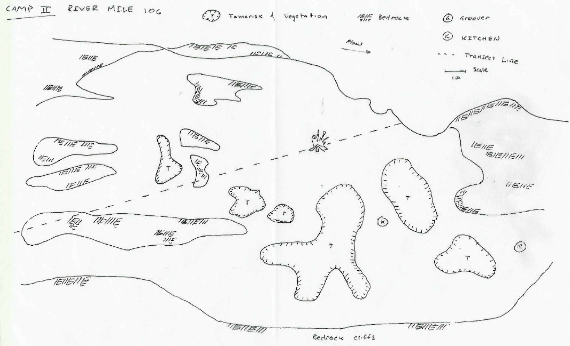
Camp II – 4 Stars
River Mile 106, River Right
This was a pleasant campsite with substantial space to pitch tents uphill of a wide circular sandbar where a campfire could be made. The kitchen was sheltered in large tamarisk grove with a path which led past the stoves to the bathroom. There were high cliffs bordering the backside of the camping area. Tents were widely spread out but usable space had less relief than Camp I, no more than 1.5 meters. Small, dispersed tamarisk groves created private areas for many tents, and all were connected by fairly well-worn trails. These groves, along with an abundance of large boulders near many of the tent sites provided good storage space and places to hang gear to dry.
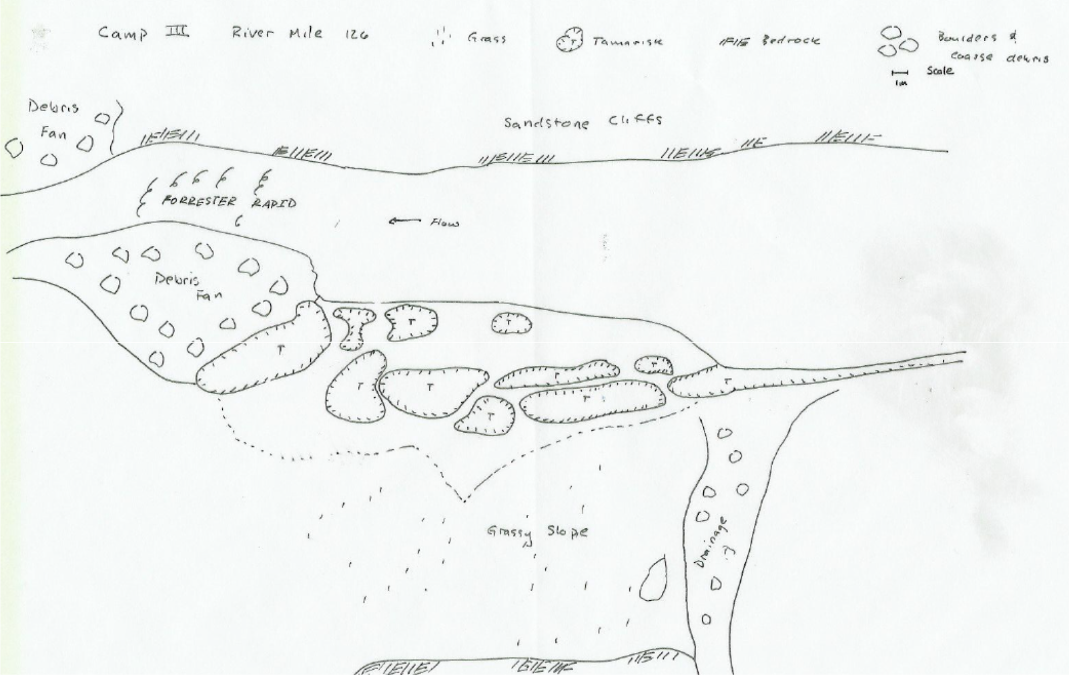
Camp III – 2 Stars
River Mile 126, River Left
This site was located directly above Forrester Rapid and had thick tamarisk bordering the upper edge of the sandbar. The low relief made this a safe place for scrubbing in the river, but the kitchen was unprotected from rain or wind which came up late in the evening. Tent sites were scarce with fairly little level ground close to the rafts or kitchen. There was also no good place to locate the bathroom facilities that wasn’t excessively far away or widely exposed.
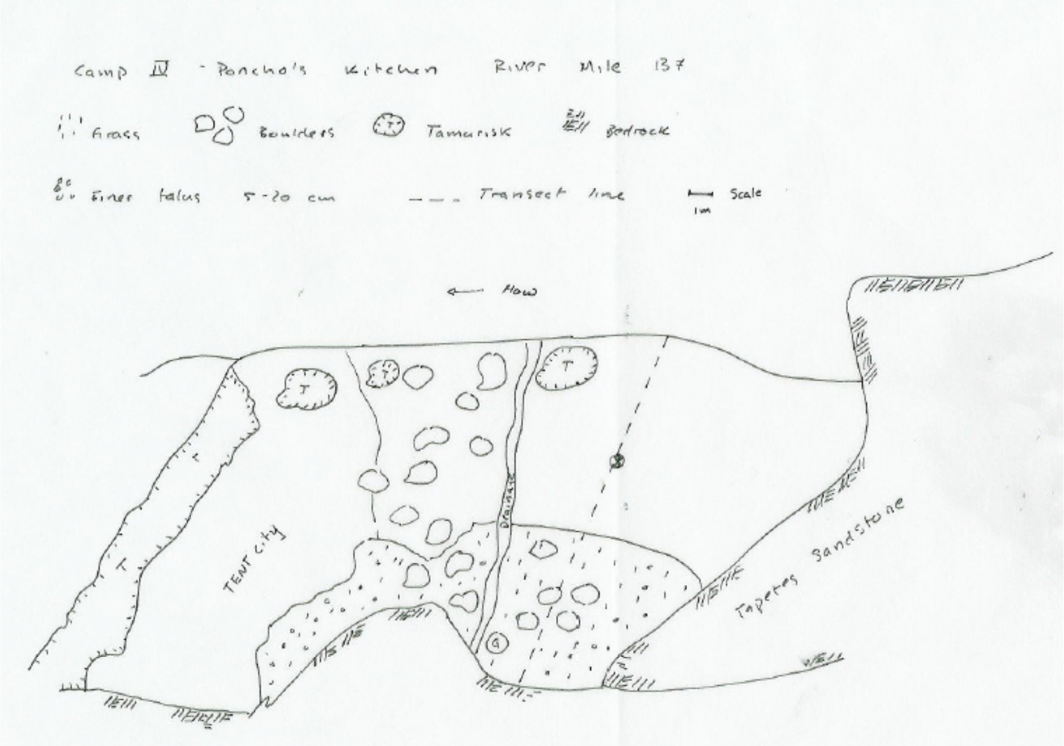
Camp IV – 5 Stars
River Mile 137, River Left
This site was just downstream of Deer Creek surrounded by Tapetes Sandstone cliffs. The relief was the highest of any campsite over the course of the entire trip with a terraced sandbar that covered 3 to 4 vertical meters. A small strip of level sand provided space for pitching tents downstream of a boulder field which separated the kitchen area from living quarters. As a bonus, the sandstone cliffs provided a shelter for cooking with a large overhang that doubled as an excellent challenge for bouldering enthusiasts.
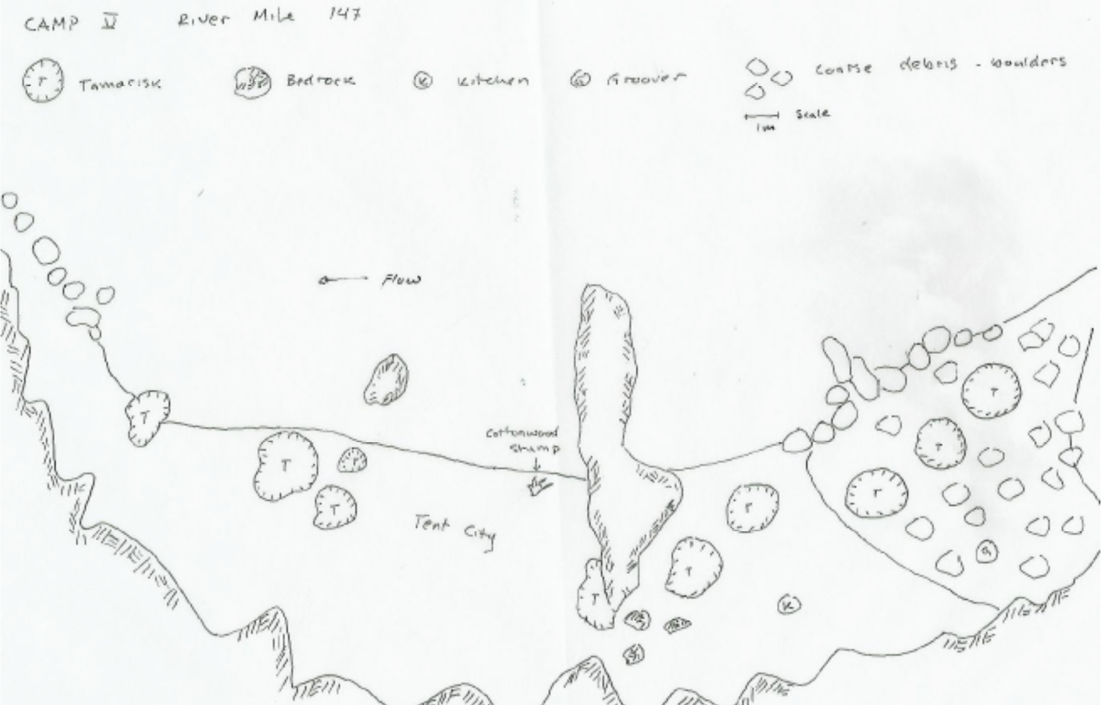
Camp V – 4 Stars
River Mile 147 – River Left
This campsite was a surprising success despite the difficulty of unloading gear after tying up for the day. The campsite itself had relatively little relief, with even sandbars no more than 10 to 15 meters wide adjacent to more sandstone cliffs. Tamarisk provided little cover, but the kitchen was sheltered against a fierce wind in the crooks of the cliffs. Bathroom quarters were tight, but private. Actually almost everything was pretty tight at this location, tents were edge to edge on a single beach and to reach the kitchen from sleeping quarters required ducking under a sharp ledge. But these events notwithstanding, the low overhangs provided shelter after dinner in which passengers could socialize, and regardless of where tents were pitched it was a short walk to the rafts, kitchen and bathroom.
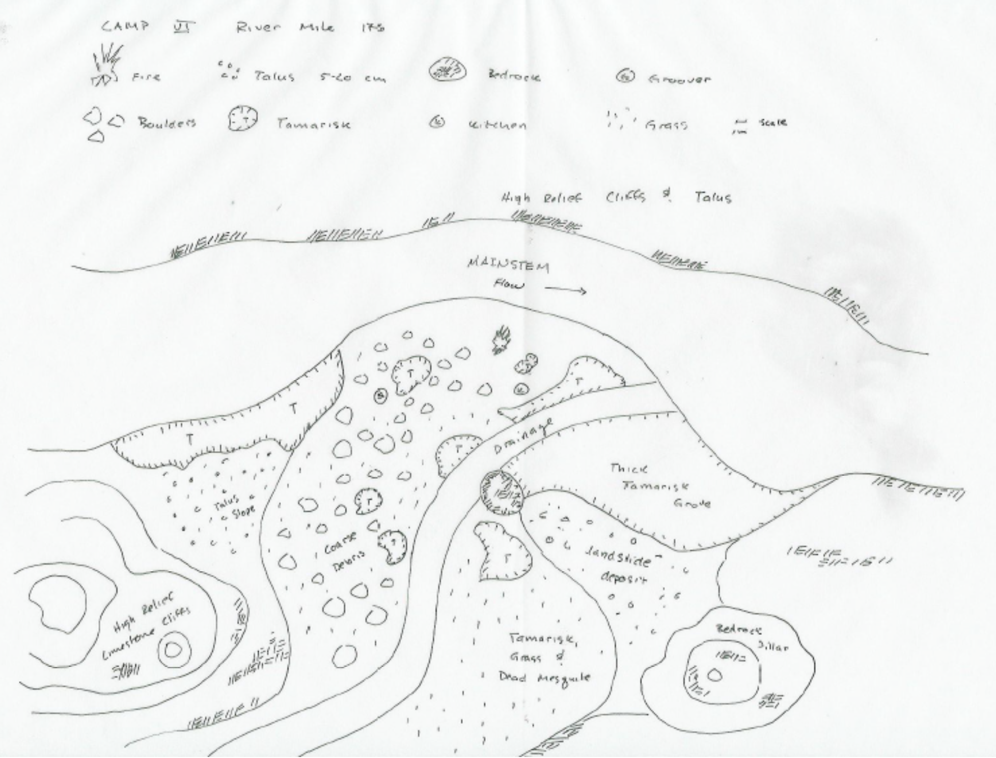
Camp VI – 2 Stars
River Mile 176, River Right
This campsite was located on a large debris fan with low relief and lots of coarse debris. Level sand was scarce and often pockmarked with boulders which promised to make sleeping uncomfortable. The wind at this site was strong and unpredictable, making the campfire temperamental and smoky. While tamarisk seemed to be everywhere, it provided coverage only for the kitchen and a single tent. The bathroom facilities were downwind, but required a relatively long and rocky walk that was tricky late at night. The bonus feature at this location was a herd of bighorn sheep (Ovis canadensis) which resided on the cliffs above the campsite and kicked rocks down to the canyon floor throughout our stay. These tent sites that did exist were adequate, but some people had to walk fairly far back to find enough level ground.
Camp VII – 3 Stars
River Mile 194, River Left
Recent deposition provided ample space for the kitchen and a campfire circle. At low water a wide flat sandbar that has lost most of its deposition to ramping flows provided space for ultimate frisbee. Relief was low; atop the new deposition the entire site was more or less flat. Tamarisk was abundant and provided good cover for bathroom facilities. Sleeping quarters were spread out but there was enough level ground for everyone to be comfortable. Red ants begin to notably increase in number and the exposed backwater marsh that formed at the backside of this campsite dramatically increased the mosquito and insect population as well.
Camp VIII – 2 Stars
River Mile 220, River Right
This was an unusual site in which a drainage had recently avulsed through the center of the usable sand on a debris fan. The recent floods in November had deposited a significant quantity of sand only for most of it to be removed by the avulsed drainage. The surface between usable sleeping space and the kitchen was highly irregular and after dark a headlamp was more or less mandatory to avoid tripping on Tamarisk roots or the concealed boulders in the drainage. The site was awash in insects, gnats, and biting No-see-ums which swarm around exposed skin during daylight hours. There were only a few Tamarisk groves, but the bathroom was well concealed and the kitchen protected from winds that never really came up. The site was a full 1.5 meters above the river water surface at 10,000 cfs, but then had very mild relief with a gentle gradient up the debris fan.
Admittedly, rating campsites on a scale of 1 to 5 stars may be considered splitting hairs when every one of them is located on the Colorado River at the bottom of the Grand Canyon, but a few common elements can be distilled from these accounts. The recent November floods that were intended to increase the size of sandbars for campers may have initially been effective, but the trout harassment flows which have followed have scoured away large volumes of sand from usable sites. Bank collapse has reduced usable space as well. Good campsites need not be large as Camp V demonstrated, but do need enough flat space for everyone to sleep comfortably. Tamarisk, its ecologic implications notwithstanding, provides valuable windbreaks and shelter when located on the downstream side of camps and has matured to at least 6 feet in height. Bedrock and very large debris remain the best shelter for privacy, wind blocking, and gear storage/drying, so sites which experience large volume depositions creating sleeping space with proximity to canyon walls or large debris are particularly desirable. Generally, more relief in campsites seems to improve the camping experience, partly because eolian sand deposits increase sleeping space, but also because these higher relief sites are effectively broken into smaller individual spaces by elevation and breaks in line of site. Other factors to consider include availability of large spaces for group activities such as campfires or frisbee, ease of transporting gear from boats to camp (particularly ability to do so without destroying the newly deposited sandbars), and availability of driftwood for campfires. Future management for campsites should continue to attempt to maximize and preserve sand deposition along the river corridor. This is particularly true at higher flow levels where sleeping and cooking space adjacent to canyon walls and bedrock cover is lacking and where eolian processes have been relatively ineffective at creating usable space.