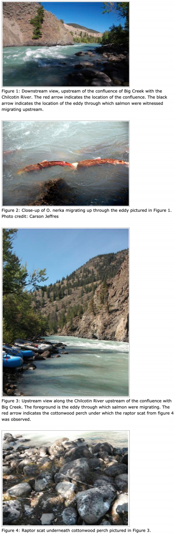
The Chilcotin River is confined at its confluence with Big Creek by the outflow of rocky debris from Big Creek on one side and by metamorphic bedrock on the other side. The Chilcotin River is reduced to a width of about 50 feet, causing very high water velocities throughout the entire channel in this reach. However, the mixing of the waters of Big Creek with the Chilcotin at the confluence creates an eddy of slower moving water that is an ideal corridor through this confined section of river for up-migrating salmon (Figure 1).
Despite low visibility in the water due to turbidity, we observed a steady procession of sockeye salmon (Onchoryhncus nerka) swimming upstream through the eddy and continuing upstream along the right bank margin through shallower, slower-moving water in the Chilcotin River (Figure 2). Some people hiked upstream along the Chilcotin and observed a similar scene in slower-moving water along the left bank of the Chilcotin. This implies either that the salmon are using slower-moving water along both sides of the channel or they are crossing through the middle of the channel at certain points to make use of the slowest water along the margins, wherever it may be. Both may be true depending on the specific conditions of the hydraulic environment at each moment of an upstream migration. Avoiding the high velocity water that dominates the majority of the channel throughout this confined reach allows the adult salmon to conserve energy for the rest of their upstream journey and for gamete production.
However, the salmon's presence in lower-velocity waters of the river's margin make them more vulnerable to predators. One of our group, Carson Jeffres, caught two sockeye in two five-minute sessions of fishing this section after waiting for a large group of salmon to pass through the narrow migration corridor. There was evidence that this particular location was frequented by other vertebrate predators, too. When we first arrived at the campsite, there was a coyote less than 50 feet from the Chilcotin River's right bank. We found bear scat along the trail following Big Creek's left bank less than half a mile upstream of the confluence with the Chilcotin River. There were a few locations with high concentrations of raptor scat directly underneath Cottonwood branches above this narrow migration corridor on the right bank of the Chilcotin River (Figures 3 and 4). It is probable that when large numbers of salmon are using this corridor that some will rest or have to wait in shallow water before continuing upstream. These fish will be extremely vulnerable to predation in the shallow water and it is likely that many predators make successful catches of the salmon due to their confinement at this particular reach.
The water velocity in the Chilcotin River around its confluence with Big Creek is the highest of any reach of that River downstream of Bidwell (Lava) Canyon and upstream of Farwell Canyon. It is a major obstacle to up-migrating salmon. The salmon choose lanes with the slowest-velocity water to pass through this challenging obstacle. This strategy presumably leaves the salmon with the most energy leftover at the end of their migration to dedicate to spawning activities (competing for mates/redd locations, gamete production, and redd protection) but results in the tradeoff of limiting their migration corridor and exposing them to predation. The salmon achieve an incredible feat of migration and fuel the mammalian and avian populations along the way.
When glacial retreat reaches a maximum during an interglacial period (such as today), the ratio shifts and high relative transport capacity causes incision into the thick aggradational layers. Maximum incision occurs at the point of maximum glacial retreat. Today's interglacial conditions have resulted in a sediment-starved system and thus deep incision - the high, steep cut banks of Big Creek. Several cycles of glacial advance and retreat, with each advance smaller than the previous, formed the stair-stepped terrace topography (Figure 3).