Spring

Chilko-Chilcotin-Fraser Rivers 2011

This year's ecogeomorphology course studied the headwater lakes and river systems of the Chilko-Chilcotin River system in British Columbia, Canada. The course was focused on developing a conceptual model that tied important physical and biological processes together based on levels of importance and understanding. To compliment the model, eleven technical chapters provided details in disciplines ranging from tectonics and glaciers to biological nitrogen cycling. An interactive map identifies locations of field work activities, interesting islands, and campsites. And of course there are many field logs (Flogs) and photos to enlighten and entertain the casual viewer.

Water Management and the Tuolumne River 2010

This applied workshop featured analyses of contemporary environmental problems in a multidisciplinary fashion. Students were exposed to both environmental science and policy, tackling some of the toughest issues facing California: water resources, multiple downstream demands, and climate change adaptation. By using the Tuolumne River as a case study, students had the opportunity to learn about the history and future of this landmark river in our nation's history.

Kobuk River 2008

This year, the Ecogeomorphology course examined the most critical issue facing arctic and sub-arctic aquatic ecosystems: global climate change. During class, the students discussed several issues in detail, reviewed published literature, and prepared individual reports for publication on Wikipedia. Following this period of classroom study, the students conducted a two-week field study of the Kobuk River watershed, located above the Arctic Circle in northern Alaska. A primary focus of this study was the status of sheefish (Stenodus leucicthys), a unique arctic fish species of limited distribution, and potential changes to its habitat due to climatic change.

Grande Ronde River 2007

Riverine ecosystems are commonly thought to exhibit relatively continuous downstream gradients in physical conditions and ecological communities. However, recent research suggests that observed longitudinal gradients in riverine ecosystem form and function are quite variable and largely dependent upon local hydrology, geomorphology and climate. The lower Grande Ronde River, which flows through regions with distinctly different geomorphic and climatic conditions, provided a great opportunity to examine the nature of longitudinal gradients in terrestrial and aquatic ecosystem characteristics.

Green River 2006

In June 2006, the Ecogeomorphology course studied the Green from the tailwaters below Flaming Gorge Dam through the Gates of Lodore, past the confluence with the unregulated Yampa River, ending at Split Mountain in Dinosaur National Monument.

Skeena River 2004

This course introduced advanced undergraduate and graduate students to multidisciplinary collaborative watershed and stream analysis through combined laboratory and field study. 
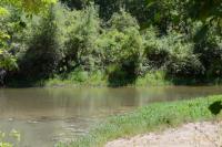
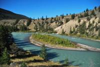
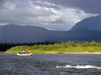
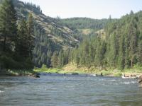
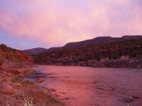
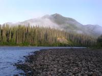
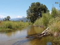
Students from diverse backgrounds worked in cooperative research teams to collect and analyze field data from the Skeena River watershed (British Columbia), one of the largest un-dammed rivers in North America (Dynesius and Nilsson 1994). These teams used field collected data to analyze geomorphic processes and test ecological hypotheses of biotic diversity. Specifically, students studied patterns of aquatic macroinvertebrate and salmonid diversity in multiple tributaries to the Skeena River.

Scott River 2003

This course seeks to introduce advanced undergraduate and graduate students to multidisciplinary collaborative watershed and stream analysis through combined laboratory and field study of a selected stream system. Students from diverse backgrounds will work in cooperative research teams to collect and analyze field data from the Scott River watershed, a tributary to the Klamath River system. These teams will use the field data to report upon a key ecological issue within the watershed: what characterizes rearing habitat for juvenile Coho salmon in the Scott River watershed and how can this be applied to on-going restoration strategies? Upon completion of the field study, students will report on their conclusions.

Copper River 2002

Taught for the first time in 2002, the Shlemon Course focuses on the analysis of a selected watershed, typically within North America. Students form collaborative, multidisciplinary teams that address one or more issues within the watershed, including the design of laboratory or field experiments. The course culminates with an extended field trip to the watershed where field experiments are conducted.

Yampa-Green 2019

The course was a multidisciplinary study of the ecology, geomorphology and management of the unregulated Yampa River in comparison with the regulated Green River. Comprised of upper-division undergraduate students and graduate students, the course brought together students from a range of biological and physical sciences to address the geology, ecology, and management of the Green River watershed. The course involved classroom instruction and literature review papers written by the graduate students on specific topics related to the Green River watershed. It culminated with a seven-day rafting trip on the Yampa and Green Rivers during which students collected and analyzed field data.

Tuolumne River 2009

The study of streams is inherently multidisciplinary involving a broad array of physical, biological and social sciences. This class will take a trip down the Tuolumne River and study the ecology of this riparian environment. Research performed on 2 separate trips (June 15-18 and June 21-24) included vegetation and substrate mapping, fish surveys, seining, and electrofishing, macroinvertebrate collection, and herpetology studies. Cross sections were developed using a laser range finder for the Mainstem Tuolumne, 2 locations on the Clavey River, 2 locations on the North Fork Tuolumne River, and near Indian Creek.