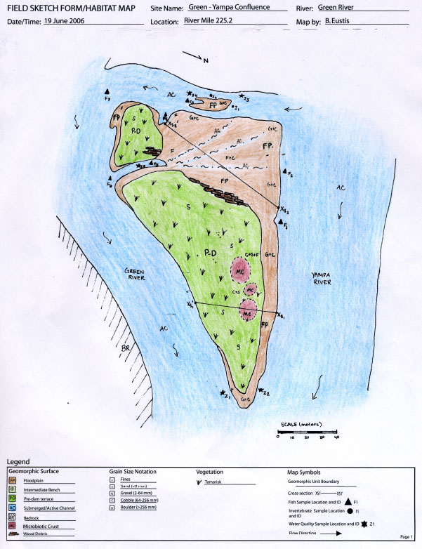
GEOMORPHIC DESCRIPTION
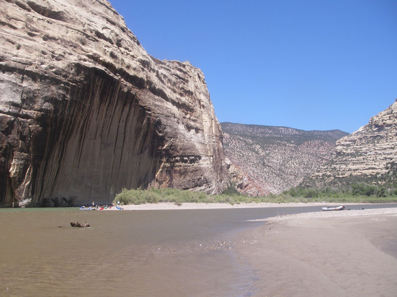
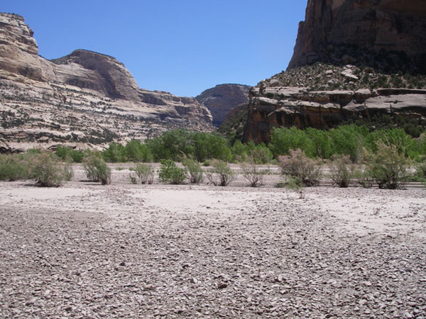
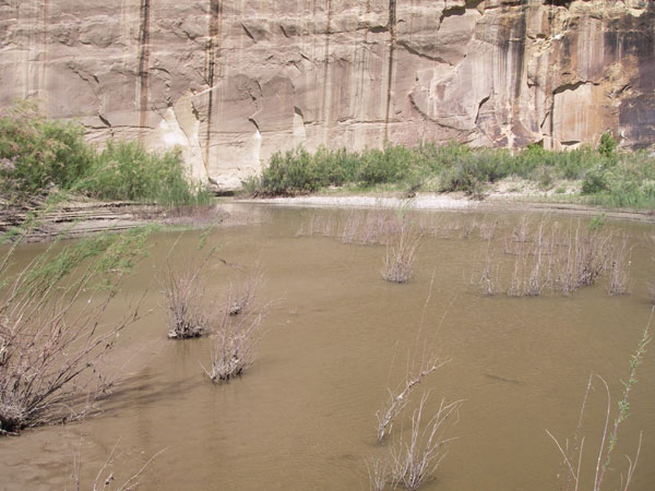
The Yampa River enters the Green River creating a large island between the Yampa River’s multiple channels. The Yampa is unregulated and therefore can transport larger and more sediment than the Green. The picture shows the more turbid water of the Yampa (right) coming to meet the clearer water of the Green (far left). Accordingly, at the confluence of the Green and Yampa rivers, larger sized deposits are apparent along the floodplain of the Yampa River side of the island while silt sized sediments are deposited on the floodplain along the Green River side of the island. Contacts between the post-dam floodplain and pre-dam terrace are also more gradational along the Yampa side of the island than on the Green River side. The pre-dam terrace in the center of the island is mostly sand and has been overtaken by tamarisk plants. Woody debris marks the edge of this pre-dam terrace. Across the Yampa River (not included in habitat map) the bank rose gradually with no distinct terraces. Fewer tamarisks and more cottonwoods, box elders, and junipers were found across the Yampa River.
RIPARIAN VEGETATION
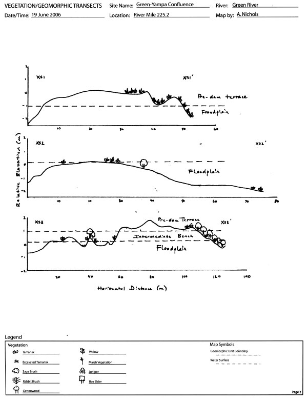
The island between the confluence of the Green and the Yampa rivers was subject to the Yampa’s natural hydrograph on the north and north-west sides and the Green rivers regulated hydrograph on the north-east side (see geomorphology map). The island was classified into two surfaces, the post-dam active terrace and the pre-dam inactive terrace. Transect 1 ran perpendicular to the Yampa River and spanned to the edge of the Green river. The post-dam terrace on the Yampa side was sparsely occupied by young tamarisk and cottonwood. Moving across the island onto the pre-dam surface and toward the Green river, tamarisk became denser and appeared to be of older age (see geomorphology cross-section). On the Green river side of the island, we also observed cutting of tamarisk possibly by beaver.
Transect 2 was constructed across the post-dam terrace created by the Yampa river. Along this transect, tamarisk and cottonwood were sparsely distributed (see geomorphology cross-section). It appeared that the portion influenced by the Yampa sparsely supported tamarisk and cottonwood recruits. The area influenced by the Green river resulted in cut-banks and dense tamarisk populations.
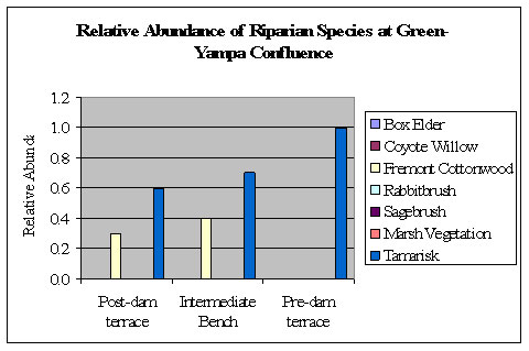
Transect 3 was constructed across the Yampa river on geomorphic surfaces not influenced by the Green river. Here the post-dam terrace of the main channel and side channels is mostly vegetated by tamarisk and cottonwood recruits. The intermediate bench was also a mixture of tamarisk and cottonwoods. The relative abundance of cottonwood increased while the relative abundance of tamarisk decreased in both the post-dam terrace and intermediate bench (Fig. 1). No marsh vegetation was seen in this region, though coyote willow was present. Box elder was also observed at higher elevations. This is the first region where we noticed mature cottonwood and mature box elder in the same region.
WATER QUALITY
Larger turbidity values were measured in the Yampa River as compared with the Green River upstream of their confluence. The difference in turbidity and color between the Yampa (left) and Green (right) is visible in this photo. The Yampa River has a higher flow rate than the Green because it is largely unregulated and snowmelt was still occurring in the watershed. The Green River had larger values of specific conductivity as compared with the diluted Yampa River. No substantial difference in water temperature between the two rivers was observed.
|
Date |
Time |
Location |
pH |
Temperature (°C) |
Specific Conductivity (mS/cm) |
Turbidity (NTU) |
% Dissolved Oxygen |
Air Temp (°C) |
|---|---|---|---|---|---|---|---|---|
|
6/19 |
10:08 AM |
Green River RM 225.4, upstream of conf. |
7.15 |
19.21 |
0.596 |
10.5 |
84.2 |
29.0 |
|
6/19 |
10:35 AM |
Green River directly upstream of Yampa conf. |
8.18 |
19.62 |
0.580 |
9.2 |
84.8 |
29.0 |
|
6/19 |
10:55 AM |
Yampa River directly before conf. |
7.24 |
19.27 |
0.157 |
30.5 |
83.9 |
29.0 |
|
6/19 |
11:20 AM |
Yampa River side channel |
7.24 |
19.36 |
0.155 |
33.5 |
83.4 |
30.0 |
|
6/19 |
11:30 AM |
Instruments Recalibrated |
|
|
|
|
|
|
|
6/19 |
11:40 AM |
Green River directly upstream of Yampa conf. |
7.17 |
20.70 |
0.578 |
10.4 |
86.0 |
30.0 |
|
6/19 |
11:45 AM |
Yampa River directly before conf. |
7.17 |
19.42 |
0.156 |
31.9 |
86.1 |
30.0 |
|
6/19 |
11:55 AM |
Yampa River side channel |
7.17 |
20.46 |
0.157 |
25.8 |
91.9 |
30.5 |
|
6/19 |
12:05 PM |
Backwater of Green River after seining |
7.17 |
23.51 |
0.482 |
40.9 |
75.0 |
30.5 |
|
6/19 |
14:30 PM |
Echo Park Ranger Station, half a mile downstream of conf. |
7.17 |
20.50 |
0.157 |
47.8 |
86.6 |
30.0 |
FISH
Seine Collection Data:
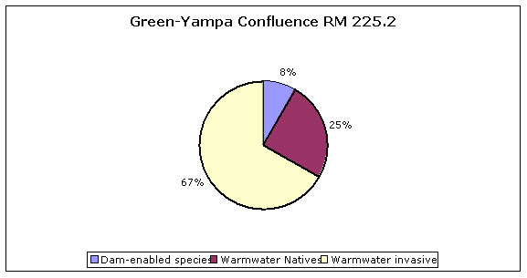
|
Species |
FL (mm) |
N |
|---|---|---|
|
Rainbow Trout |
45 |
1 |
|
Smallmouth Bass |
52 |
1 |
|
Bluegill |
36-48 |
9 |
|
Bluegill-Green hybrid |
34-39 |
2 |
|
Speckled Dace |
42-56 |
14 |
|
Flannelmounth Sucker |
36-87 |
51 |
|
Red and Sand Shiner |
23-59 |
102 |
|
White Sucker |
58-108 |
5 |
|
Roundtail Chub |
40-68 |
55 |
|
Redside Shiner |
80 |
1 |
General Comments:
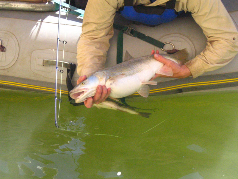
Perhaps one of the most exciting moments of our adventure occurred when a Colorado pikeminnow (Figure 1) was caught at the point of first contact between the Yampa and Green Rivers. The pikeminnow took a Mann’s Baby 1-minus, Grey Ghost pattern, fished on 14-pound spiderwire. The pikeminnow appeared to be in good health, measured 635mm fork length, and displayed faint breeding coloration on its fins. The pikeminnow was holding in 1-4 feet of water among downed cottonwood branches when it took the lure. The fish was released unharmed. In addition to the highly anticipated appearance of the Colorado pikeminnow we began to see many other small cyprinids appear in the backwaters, along with several centrarchids species. Overall the diversity of species found at the confluence was much greater than in the areas preceding the Yampa River.
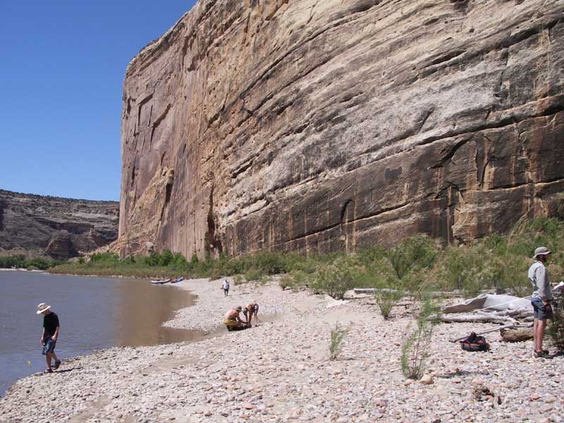
Seine pulls here yielded the largest diversity of fish sampled during our research. Figure 2 shows a siene sampling location.
AQUATIC INVERTEBRATES
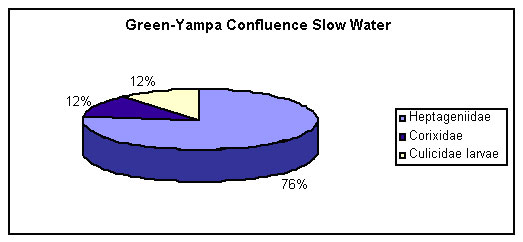
Sampling sites were located in the cross channel along the upstream edge of the island located at the confluence of the Yampa and Green Rivers. We sampled both a shallow riffle and deeper, slow water habitat. Substrate size and aquatic vegetation cover were estimated.
Habitat A - Slow water
Substrate: 40% silt, 10%sand, 50% gravel
Vegetation: Submerged dead tamarisk stems
Diversity: 0.68
Habitat B - Riffle
Substrate: 20% sand, 40% gravel, 40% cobble
Vegetation: Very little, some dead tamarisk stems
Diversity: 0.26
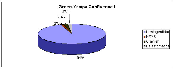
Comments: We were surprised to find such low diversity at this site, which consisted primarily of early instars of heptageniid larvae (flatheaded mayflies). Adult mosquitoes were extremely abundant at this site, as were larval and juvenile fish. We hypothesize that the variability of the Yampa and the highly dynamic nature of flows at this site have the effect of lowering aquatic invertebrate diversity and abundance.
BIRDS, MAMMALS, REPTILES, AND AMPHIBIANS
We surveyed this site for an hour in the mid-morning with sunny but windy weather conditions. This site was a sandbar island with dense tamarisk on the Green River ride and a rocky edge on the Yampa River side. Birds were identified by visual sightings, or song or track recognition. Reptiles were identified by visual sightings. Mammals were identified by visual sightings or track recognition.
Mud encircling the island allowed easy track identification. The species composition at this site was limited to animals that could cross the rivers. Opposite the island and across the Green River, Steamboat Rock provided ideal habitat for cliff shallows. The box elder on a sandbar below Steamboat Rock provided habitat for ravens.
|
Common Name |
Scientific Name |
# |
ID |
Location |
|---|---|---|---|---|
|
Canada goose |
Branta canadensis |
5+ |
tracks/scat |
bank |
|
Cliff swallow |
Petrochelidon pyrrhonota |
20+ |
sight |
air |
|
Common raven |
Corvus corax |
5 |
sight |
box elder |
|
Spotted sandpiper |
Actitis macularia |
5+ |
tracks |
edge |
|
Violet-green swallow |
Tachycineta thalassina |
5+ |
sight |
air |
|
Desert or mountain cottontail |
Sylvilagus audubonii or S.nuttalii |
2 |
sight |
tamarisk |
|
Unidentified deer |
Odocoileus spp. |
2 |
tracks |
bank |
|
Western terrestrial garter snake |
Thamnophis elegans |
1 |
sight |
bank |
We extended our Green – Yampa confluence site to encompass an area across the Yampa River. We surveyed this site for an hour around noon with sunny and windy weather conditions. The habitat consisted of box elder, cottonwood, juniper, and rocky ledges. Bird species were identified by visual sightings, or song or track recognition. Reptiles were identified by visual sightings. Mammals were identified only by track recognition.
At this site, a high flow channel provided semidry sand for mammal track identification. We observed more lizards here than anywhere else, and we also found a group of young toads in an active floodplain, each approximately 2cm in length. The high abundance of juniper at this site provided suitable habitat for black throated gray warblers.
|
Common Name |
Scientific Name |
# |
ID |
Location |
|---|---|---|---|---|
|
Black-throated gray warbler |
Dendroica nigrescens |
20+ |
sound |
junipers |
|
Great blue heron |
Ardea herodias |
1 |
tracks |
edge |
|
Say's phoebe |
Sayornis saya |
2 |
sight |
junipers |
|
Song sparrow |
Melospiza melodia |
1 |
sight |
junipers |
|
Spotted sandpiper |
Actitis macularia |
1 |
tracks |
edge |
|
Mountain lion |
Felis concolor |
1 |
tracks |
edge |
|
Muskrat |
Ondatra zibethicus |
1 |
tracks |
edge |
|
Unidentified deer |
Odocoileus spp. |
1 |
tracks |
edge |
|
Eastern fence lizard |
Sceloporous undulatus |
4 |
sight |
rocks |
|
Unidentified lizard |
unknown |
2 |
sight |
rocks |
|
Western terrestrial garter snake |
Thamnophis elegans |
1 |
sight |
edge |
|
Woodhouse's toad |
Bufo woodhousei |
10+ |
sight |
edge |