INTRODUCTION
Glacial river systems are commonly characterized as being relatively unproductive aquatic environments (Murphy et al. 1989). The Copper River in Alaska, with impressive runs of five Pacific salmon species, appears to defy this commonly held model. As part of the UC Davis Roy Shlemon course in watershed ecology (Geology 199, Profs. J. Mount and P. Moyle, instructors), we attempted to gain a better understanding of mechanisms that may be the basis of this unexpected productivity. We aimed to gain insights into what allows the fish of this system to thrive in such harsh environmental conditions and how the fish communities of the Copper River system change from the headwaters downstream into the estuary.
METHODS:
Sampling was conducted at a series of locations during a rafting expedition that started on the Kennicot River on June 28, 2002, passed through parts of the Nazina and Chitina River and then wound up going down the main steam Copper to Flagg Point, ending on July 8, 2002.. Location of each sampling site can be found at Appendix B. At each site, sampling for fish and invertebrates was conducted by a variety of techniques as time allowed and the habitat of the sampling area mapped. The results of the invertebrate sampling are reported separately.
The sampling methods varied depending on the depth, water velocity, and water clarity. Methods also differed according to the target species and age class of fish. In the shallow backwaters, side channels, and small tributaries, a 30 X 4-foot beach seine with 1⁄4 in mesh and a 4ft bag was the primary method of catching juvenile salmon, round whitefish, and longnose sucker. Two people, one on each end, pulled the seine through the water until they reached the shore, beaching the seine on the dry ground. Once the seine was on the ground, the bag was opened and the fish captured were transferred to a water-filled bucket until they could be identified and measured. Sampling smaller streams was accomplished with a 10 x4 ft x1/8 in mesh seine. The smaller seine was used in two different ways. In one method, the seine was pulled upstream by two people and then lifted out of the water. With the second method, the seine as held flat in the water and close to the bottom, while other people drove the fish into the net, to be transferred to a bucket. When sampling small, slow moving water, a small cast net was used to capture fish, although it was rarely successful. To sample adult salmon and arctic grayling, hook and line (specifically fly fishing) methods were used. This approach was used because it was the most effective method to sample the deeper, swifter habitats of the adult fish. Once the fish were caught, they were either measured and released or kept for diet analysis. Each sampling technique was employed as dictated by the conditions encountered. All juvenile salmonids were identified using a field guide that contained photographs and drawings for comparisons.
Where time permitted, habitat maps were sketched of the sampling sites. The names of the “River Styles” are given in italics in the text with a format consistent with that found in (Wheaton 2002). Each habitat assessment included a multi-scalar assessment of habitat conditions spanning from the watershed scale down to the hydraulic and geomorphic units that comprise the reach scale. Habitat maps were sketched of the sampling sites and then segregated by geomorphic units (bar, pool, riffle, etc.) and hydraulic units (uniform flow and substrate). Specific fish sampling locations at each site were identified on the maps and species found were listed to help illustrate habitat utilization of juveniles salmonids and other fishes Appendix A.
SITE DESCRIPTONS:
McCarthy Put-In
Data at this site was collected from the Kennicott River and from a clear tributary named by locals as “Clear Creek.” The habitat sampled on the Kennicott River consisted of a slow backwater area. As with most main channel habitats encountered, the water here was very turbid (secchi depth 15 mm) and extremely cold (0.6°C). The section sampled is located approximately 150 meters below the Kennicott River Bridge. A cast net was used to sample fish at this location. No fish were captured in this main channel habitat. A second location at this site consisted of a clearwater hillslope non-glacial tributary, located about 300 meters east of the previous Kennicott River site. Water temperatures in this tributary were much warmer (ca. 10-12 °C?) than in the Kennicott River, and water clarity in this stream was excellent. Juvenile Dolly Varden (Salvelinus malma) were abundant in the small side channel, as well as in a larger pool near the foot bridge upstream. All the fish captured were small (25-35 mm FL) juveniles in small side channels <25 cm deep although larger fish were observed in deeper water.
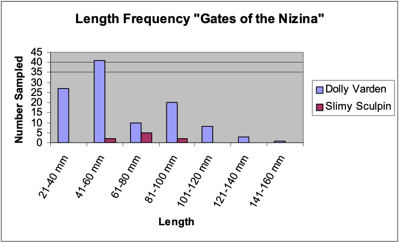
Gates of the Nizina
The Gates of the Nizina site consisted of several different habitats just below the confluence of the Kennicott and Nazina rivers. A landscape unit assessment (figure A1) showed the active braided main channel of the Nizina and its confluence with the steeper gradient braided main channel of the Kennicott River slicing through a broad braid plain. The braid plain itself was incised 100 to 150 m into an even broader glacial outwash plain and flanked on both sides by over-steepen slopes. The higher gradient Kennicot appeared to provide a head differential large enough to induce a hyporheic (subsurface) flow through the gravels and sediments of the braid plain. The hyporheic flow or water through the main channel braid plain appeared to filter very turbid water of the main channels and reemerge as clear water in remnant braid channels and side channels of the otherwise dry network of braid plain channels. Where these clearwater hyporheic channels were connected with the main channels, rearing habitat for juvenile salmonids was produced. Juvenile Dolly Varden and adult slimy sculpin (Cottus cognatus) were the only species present (figure 1).
The first area sampled was a small side channel of the Nizina River. This section was slower moving and fairly shallow compared to the main channel Nizina. The water here was cold (2.3°C) and very turbid
(secchi depth 25 mm). Dolly Varden (80-120 mm FL) were common in this stretch, with most fish inhabiting the channel margins and a backwater area at the mouth of a small clearwater hyporheic fed braid plain channel. Slimy sculpin were found in swift riffle areas, while Dolly Varden occurred mostly in slower habitats adjacent to swift currents (figure A4). Stomach contents from several Dolly Varden included aquatic insect larvae from the orders Plecoptera, Ephemeroptera, and Diptera. However, prey were few in each stomach and the fish were skinny and pale.
The second habitat sampled was a small clearwater hyporheic fed braid plain channel (figure A2 and A3). Due to the hyporheic origin of the water in this channel, it lacked turbidity and contained an abundance of juvenile Dolly Varden and a few slimy sculpin. Temperatures in this area were much warmer than those of the Nizina side channel. Most fish were found in the longer, deeper pools, with fewer fish in the runs and riffle areas. Algal growth (mainly filamentous green algae) was abundant, and some cover was available from streamside vegetation. Stomach contents of one juvenile Dolly Varden (length?) revealed adult mosquitoes, Chironomidae larvae and another fish, presumably a smaller Dolly Varden.
One final sampling location in this site included a second braid plain channel of the Nizina, located approximately 1 km below the above-mentioned clearwater tributary (no habitat map). This second braid plain channel was very similar in character to the previously described channel, except for the absence of clearwater from hyporheic flow. A mixture of riffles and runs were sampled, but no fish were found.
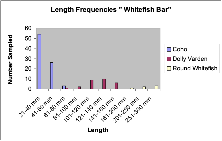
Whitefish Bar
This site was characterized by a mix of small (1-4 m wide) network of remnant braid plain channels, most of which were fed (at the time of sampling) entirely by hyporheic flow through the braid plain and drained clear water back into the turbid Nizina River (figure A5). Streamside vegetation consisted of horsetails, willows, grasses and even some aquatic mosses (presumably Fontinalis sp.), which provided decent cover for small fish. Algal growth was abundant. Water temperatures were significantly warmer than in the adjacent Nizina River while water clarity was high. A mosaic of pools, riffles, bars and glides comprised the geomorphic units of the site. The higher gradient riffles, bars and glides showed highly bimodal substrate compositions of silt and small cobble; whereas the pools and low gradient area with scarcely perceptible flow were primarily silt. Both juvenile coho salmon (Oncorhynchus kisutch) and Dolly Varden were found, primarily in riffles, but the area was dominated by juvenile coho salmon (figure 2).
Adjacent to the above site and on the edge of the braid plain, a side channel slough was sampled; it was still connected to the Nazina River via surface flow at both the upstream and downstream ends . In this reach, water clarity was only slightly better than the main stem Nizina, but the depth was much greater, temperatures were lower, and little to no cover existed. Several fish species were found to inhabit this reach, including Dolly Varden, round whitefish (Prosopium cylindraceum), slimy sculpin, and coho salmon. All of the fish captured in this transition zone were considerably larger than those inhabiting the upper areas of the clearwater tributary. Diet of two Dolly Varden included juvenile coho salmon, Chironomidae larvae and other various insects.
Nizina Gorge
Before the Nizina River’s confluence with the Chitina River, the Nizina River transitions from a broad, braided, multi-channel network incised into a glacial outwash plain (as described in previous to sites) to a narrow, single channel gorge confined almost entirely on both sides by bedrock canyon walls carved deeper into a glacial outwash plain. The high gradient of the Nizina Gorge provided some of the only real whitewater sampled. The most important aspect of this site is that it was a section of main channel habitat that we were able to sample, although not very effectively. The area sampled was a slow eddy formed at the end of a cobble and gravel bar formed on river right on the inside of a bend near the transition to a strong left bend in the river. Average depth was 0.6 meters with an irregular mix of large cobble and gravel substrate. Water clarity was again very poor. Two seine hauls returned only one 115 mm SL Dolly Varden. Most of our observations suggest few fish inhabit the main channels of these glacial rivers, so these results were not surprising.
Confluence Camp
Habitats sampled near the confluence of the Chitina and Nizina Rivers consisted of a series of backwaters and small sloughs formed by remnant channels slicing through the braid plain of the Chitina River. The Chitina River is roughly twice the size of the Nizina and boasts a broad (1-1.5 km wide) braid plain in addition to its heavily braided main channel near its confluence with the Nizina. The Chitina is also incised 100-200 m into a broad glacial outwash plain valley, which is flanked to the North by the Wrangell- St. Elias Mountains and more immediately to the south by the Chugach Range. Visual observations the night before the habitats were sampled showed a series of clear hyporheic-fed, disconnected pools, which overnight became inundated with turbid river water when the surrounding river levels rose the next day. Large numbers of juvenile coho were observed in the clear pools before they were connected the next morning when the river level rose overnight. Sampling efforts included seining the margins of the Chitina River, as well as the small bays and inlets in the gravel bars. Water clarity in these areas was very low. The substrate was mostly mud and silt with some cobble. Very few fish were found in the area. Some juvenile Coho salmon and two Dolly Varden were found.
Skull Creek
Skull Creek is a non-glacial hillslope tributary that drains northerly out of the Chugach Range into the Chitina River on river left. Skull Creek was characterized by very clear, fast moving water. The substrate was dominated by large cobble, with some smaller cobbles and some gravel. Large woody debris was abundant in the channel and bank side vegetation was rather large and very thick. Overhanging vegetation provided ample cover along the banks. Other than the inherently steep gradient of the reach, the habitat appeared very suitable for fish. Hook and line sampling was chosen as the sampling method, which returned no results. No fish were observed in the clear water as well.
Gilakina River
The Gilakina River is a substantial non-glacial hillslope tributary that drains southerly out of the Crystalline hills and a glacial outwash plain into the Chitina River on river right. Water clarity was excellent in the upper reaches, while it was only fair in the lower reaches near the mouth where it joined the Chitina River. The abundant streamside vegetation and woody debris provided the resident fish with ample cover. Habitats in the stream consisted mostly of riffle/run complexes, with stretches of slow water near the mouth. A combination of seining and hook and line sampling returned round whitefish (1), Slimy sculpin (1), Dolly Varden (2), Arctic Grayling (1) and many (50+) juvenile Coho salmon. The coho (25-35 mm FL) were all in one small pool in a side channel completely overhung with bushes and no longer connected to the main river. In the mouth of the creek, approximately 45 adult Chinook salmon were observed.
Anticipation Creek (Cabin Camp)
Although it appeared at first to be a small but inhabitable hillslope non-glacial tributary draining clearwater northerly out of the Chugach into the Chitina on river left, this steeply graded stream did not show many signs of fish life. The canopy above the stream was extremely dense, shading nearly 100 percent of the stream. The substrate was rather large, resulting from several landslides in a steeply walled canyon upstream of the mouth. Woody debris in the stream was heavy at times.. There were no pools, only continuous cascades and riffles. Hook and line sampling was not effective due to the tight canopy. Other sampling methods were not employed. No fish were captured or observed.
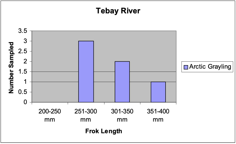
Tebay River
This larger hillslope glacial tributary drains a significant watershed north out of the Chugach range and into the Chitina on river left. Its glacial origin was apparent with the slight glacial blue tint, but turbidity was modest and clarity clear compared to other glacial tributaries in the area (perhaps muted by the influence of its own abundance of non-glacial clearwater tributaries). Hook and line (fly fishing gear) was chosen as the preferred sampling method here. Kick sampling with the 10 ft seine produced no fish. The area most heavily sampled was located approximately 150 meters upstream of the confluence with the Chitina River. The sampling site consisted of a slower and deeper section of the river, in between two fast riffles. Sampling efforts returned several large Arctic grayling up to 373mm fork length (figure 3).
Moose Narrows
This site consisted of a remnant side channel of the Chitina River, approximately 15 meters wide. Overall, this area was characterized by poor fish habitat. Water clarity was low (<50 mm secchi depth)as was bank side vegetation. The substrate was almost entirely smooth, soft mud and silt with very little gravel or cobble. There were no clearwater tributaries within close range of this sampling site and if hyporheic flow was present it took place over such a short distance from the turbid main channel that it was ineffective at filtering the water as observed at previous sampling locations. Several hauls using the 30’ beach seines resulted in no capture of fish.
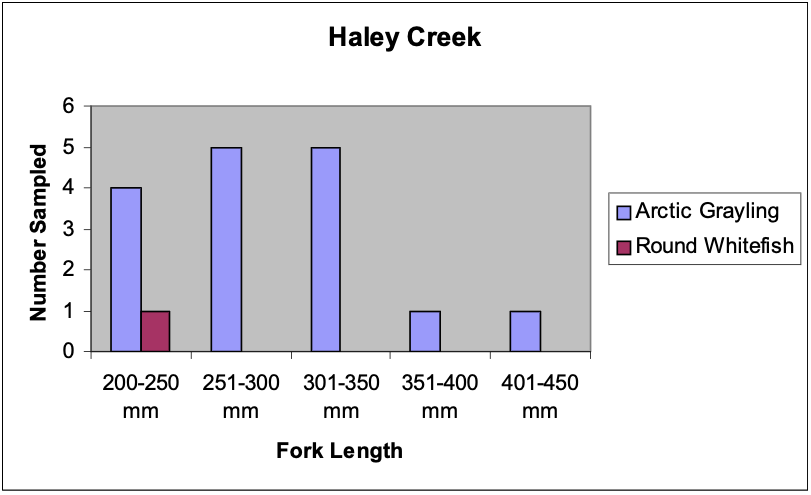
Haley Creek
This hillslope glacial tributary to the Copper River pouring out of the Chugach Range had clear water and a large population of arctic grayling, as well as a few round whitefish. There is a large (10+ m) waterfall that limits the upstream migration approximately 250 meters upstream from the mouth of the creek. The arctic grayling were observed to be feeding on the surface regularly, presumably on material blown in by the strong wind. . The fish were then sampled using hook and line method (fly fishing gear) (figure 4). The stomachs of arctic grayling were packed with a mixture of terrestrial debris (sticks, leaves, etc.) and terrestrial insects, especially beetles. A large school of adult sockeye salmon was also noted to be holding at the mouth of the creek.
Desperation Camp
No fish sampling was attempted here.
Uranatina River
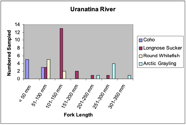
The Uranatina River is a non-glacial hillslope tributary that drains easterly out of the Chugach range into the Copper River on river right. Sampling of this site consisted of various portions of the distributary network of channels draining the alluvial fan of the Uranatina and a slough and backwaters along its mouth at the Copper River (figure A7). Streamside vegetation was moderate, but did not provide abundant overhanging cover (where sampling was performed). The substrate consisted of bimodal mixes of medium to small cobble, gravel or sand and silt across the fan and primarily sand or silt in the slough. Sampling efforts at this site covered a variety of habitats, including the mixing front of the turbid Copper and the Uranatina in the slough and riffles and chutes in the distributary channel network across the fan. Juvenile Coho salmon were found to be abundant in the clearwater areas adjacent to darkly colored glacial waters near the mouth. Longnose sucker were abundant near the mouth, but inhabited the more turbid and low gradient areas. Upstream of the confluence, hook and line sampling returned several Arctic grayling. A 10’ seine was also used in this area to locate slimy sculpin and round whitefish in riffle habitat (figure 5). In addition, some small (<25 mm FL) salmonids were observed in some clear backwaters, but were not identified.
Beaver Lagoon
This site consisted of a shallow backwater beaver lagoon adjacent to the main channel of the Copper with current entering and exiting the still water area through a narrow (2 m wide) single opening to the main channel (figure A8). The water in the lagoon was very turbid and similar to the water in the main channel. Sampling took place from a small, submerged island to the grass covered shore. Sampling was limited the shallow edges of the lagoon. Substrate appeared dominated entirely by silt and a thick alder forest flanked the lagoon on all sides. The sampling method was beach seining. In three seine hauls coho salmon, round whitefish and longnose sucker were found in small numbers (lengths? No need for graph).
Dewey Creek Camp
This creek appeared to be a moderate size hillslope glacial tributary with a steep gradient. No fish sampling was accomplished at this location.
Friends Creek
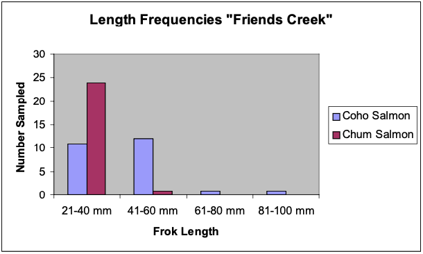
This short, steep unnamed hillslope glacial tributary flowed almost directly out of a glacier (approximately 1 km upslope) and produced a steep alluvial fan distributary network of channels at its confluence with the Copper River on river left (site A9). The habitat accessible to fish was limited to the side channels and sloughs at the mouth of the creek with the Copper River and the lower gradient riffles at the toe of the alluvial fan. Substrates on the alluvial fan were coarse with large cobble or small boulders and became less coarse towards the toe of the fan transitioning into a bimodal mix of gravel and silt. The mouth of the creek was almost entirely comprised of silt. Vegetation was only abundant on one stream bank, and a large gravel bar formed the other bank. “Friends Creek” split into two channels at the confluence. One channel emptied almost immediately into the Copper River with approximately 5 meters of available habitat, while the other formed a longer, deeper channel about 70 meters long. Most of the fish located at this site inhabited the mouth of this longer channel, with no fish observed along its length. As with previous sites, areas where clear waters mixed with turbid glacial waters produced good numbers of fish. Where three successive seine hauls were made, one in clear water, one in turbid water, and one in the transition zone, only the transition zone haul produced fish (figure 6). Juvenile coho salmon were found near the mouth of this stream. Juvenile chum salmon (O. keta) appeared quite abundant in the area where the steeply graded part of the stream transitioned into the long, flat run. Slimy sculpin were found in the section of inhabitable fast water, shortly before the confluence with the Copper River. A combination of 10’ and 30’ beach seines were used to capture fish at this site.
Cleave Creek
Cleave Creek was another hillslope glacial tributary with an alluvial fan but more turbid water than Friends Creek at its confluence with the Copper River on river right. The mouth of the creek is a distributary network of channels with many channels and high sediment load. The water in the creek was found to have a secchi reading of 38mm, while the main stem of the Copper River had a reading of 20mm. The reading means that Cleave creek is slightly clearer than the main stem of the Copper River. In the braided channels of the delta seines were used to sample the creek. In one of the channels, two rather pale and skinny Dolly Varden were found. No fish were found in the other channels that were sampled.
Peninsula Camp
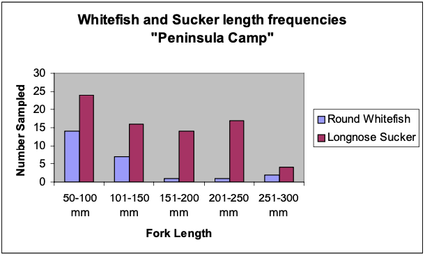
Sampling efforts at this location covered a variety of habitats. The first area sampled consisted of a shallow backwater, formed off a side channel of the Copper River. Several small bays that contained fairly clear (secchi depth probably 50 mm) water (from sediment settling out) which then mixed with turbid glacial water were sampled using a 30’ beach seine. Streamside vegetation in this area was very rare, and the substrate consisted mostly of cobble, gravel and silt. Overall, the habitat complexity of this location was very low. A small number of juvenile whitefish and coho salmon were captured. Longnose sucker were abundant in this backwater, and all appeared to be fairly healthy and of good size.
The second sampling area was located along the valley margins of the Copper River braid plain with three distinct tributaries joining to form a larger tributary, which joined up roughly 200 m downstream with an active braided main channel of the Copper River (figure A10). The primary tributary of the three was a turbid hillslope glacial tributaries, which drained westerly and was joined by two braid plain channels with clearwater (one draining southerly and the other southeasterly). The channel draining southeasterly was of similar nature to the other hyporheic fed braid plain channels observed earlier in the trip. The origin of the channel draining southerly was uncertain and a hiking reconnaissance was performed to determine its origin. The channel was followed northerly along the eastern edge of the braid plain with slight meandering and a mix of glides runs, riffles and shallow pools for roughly 1.5 km until the source of the clearwater was found. A large beaver pond backed up by a 1-meter high beaver dam appeared to be the primary source of water with possible smaller hyporheic inputs from the braid plain along the right edge of the channel. However, at the toe of the beaver dam a sizable second channel joined in from the east. Although the channel was dry at the time, it appeared to be a perennial hillslope glacial tributary contributing much to the size, channel geometry and substrate composition of the braid plain channel.
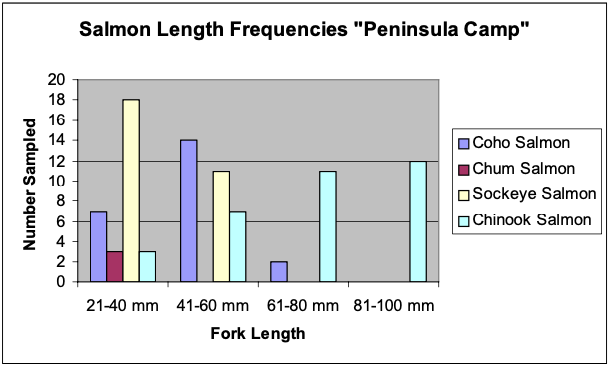
At the confluence of the tributaries of mixed origin, sampling along the mixing line produced a variety of fish, including juvenile chinook salmon, juvenile sockeye salmon (O nerka), round whitefish, slimy sculpin and longnose sucker (figure 7, 8). Hook and line sampling from the previous day resulted in the capture of some small (ca 15 cm FL) arctic grayling as well. The habitat comprising this area consisted of well undercut banks, thick streamside grasses and some willows. Substrates here consisted mostly of gravel and some silt. Current speeds were moderate at most, providing ample opportunity for fish to colonize the area. Seining upstream of the confluence of the spring creek with the glacial stream became increasingly difficult, resulting in no fish captured. However, fish may have been likely to inhabit the area.
The mixed tributary downstream of the confluence described above then joined a long side channel Copper River. Most fish in this tributary were found in small backwater refuges and mixing lines in the vicinity of the mouth. Longnose sucker and round whitefish were abundant near the mouth, where clear water began to mix with the Copper River side channel. Juvenile chum salmon and sockeye salmon were found in good numbers inhabiting a small, clear, backwater cove near the mouth of the tributary, along with a few juvenile coho and suckers (figure 7, 8). This area had abundant streamside grasses to afford cover to small fish. Juvenile chinook salmon were fairly abundant in the Copper River side channel, in the area just downstream of the mixed tributary input. The side channel in this area had several woody debris piles, a steep cliff wall on one side, and a large open gravel bar forming the other bank.
Bremner Camp (Dust Bowl Camp)
A small-unnamed creek was present at camp. The water was clear and cold. The creek has a steep gradient, and medium sized cobble substrate. The creek may have been inhabitable by fish, but contained no habitat deeper than 40 cm. Due to time constraints no fish sampling was done.
Upper Miles Lake
This sampling site was at the upper end of Miles Lake. Small side channels, main stem margins, and backwaters were sampled at this site. The water was very turbid and little current was present in the sampling area. The substrate was very fine and soft. Beach seines and cast nets were used to sample the area. No fish were found.
Childs Glacier Distributary
The glacial tributary was fed by melt water from the Childs Glacier and formed a distributary channel network at its mouth with the main stem of the Copper River Delta approximately 3 km downstream of Childs glacier (figure A11). The distributary channel network was incised into a terrace delta outwash plain. The water had a milky glacial color, but better clarity than the main channel. The main channel of the creek was too deep and fast to sample. Beach seines were used to sample the mixing fronts, backwaters and margins of the main channel. In these habitats, juveniles of coho salmon, sockeye salmon, chinook salmon, and round whitefish were found. In a small hyporheic flow channel small (<25 mm FL) Dolly Varden were captured using a small aquarium net. In the hyporheic channel large amounts of vegetation were present.
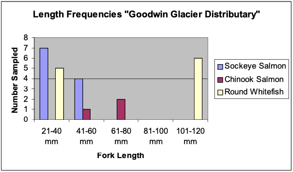
Goodwin Glacier Distributary (Cobble Bar and Grill)
The Goodwin Glacier distributary was very similar to the Childs Glacier Distributary. The sample area was again fed by a glacial tributary draining the Goodwin Glacier and forming a distributary channel network at its mouth in the Copper River Delta (figure A12). The water was turbid, but considerably clearer than the main channel. At the mouth of the creek there was 3 main channels and many other small channels present. Both the 30 foot beach seine and the 10 foot beach seine were used. The larger whitefish were caught closer to the mouth of the stream in the one of the main channels. Most of the salmon and smaller whitefish were found higher up and generally in the smaller channels (figure 9). Slimy sculpin were found in the smaller faster moving channels up higher from the mouth of the stream. The main channels up higher were too fast to sample using a seine.
DISCUSSION
The productivity of the Copper River basin was hypothesized to be dependent on the clear water habitat outside of the turbid main channels of the glacial rivers. Clearwater habitats included settled backwaters of the main channels, clearwater glacial and non-glacial tributaries and braid plain channels of hyporheic origin. After reviewing the datasheets and habitat notes, several reoccurring themes became clear. The vast majority of fish that were captured throughout the system were all associated with clear water habitats of some type. Habitats sampled along the turbid braided main channels rarely produced any fish. However, when clear water habitats were in close proximity to these turbid main channel areas, fish were often found inhabiting these areas. Mixing zones of glacial and clear waters were often the most productive in terms of numbers of species and total numbers of fish captured. Larger fish were found in the more turbid waters of the main channel, but were often much thinner than their clear water counterparts. Longnose sucker and slimy sculpin, two species which are resident, rather than anandromous fishes, occurred frequently throughout the Copper River system.
These observations suggested the importance of clearwater habitats associated with hyporheic flows and small tributaries in supporting fish populations in this glacial system, at least in the lower reaches. In upstream areas of the mainstem Copper River, large lakes and their associated stream systems were presumably the key habitat for sockeye salmon, although the small size of the sockeye we collected suggests some spawning and rearing in other habitats as well.
Hyporheic fed braid plain channels and both glacial and non-glacial tributaries with relatively clearwater may have acted as important rearing grounds for juvenile salmonids and spawning grounds for adult salmonids. It appeared that fish utilized the shallow clear waters to grow quickly, until the risk of predation became too high. In order to decrease the risk of predation, the larger fish may then have migrated to the boundary of the clear and turbid waters. These mixing zones may have decreased the risk of predation, by providing cover from predators. Fish in these areas appeared to move into the clear water to feed. For example, a Dolly Varden sampled from turbid water directly influenced by a hyporheic channel inhabited by juvenile coho salmon contained a juvenile coho salmon in its stomach. No juvenile coho were found in the turbid water, but only in the adjacent clear water habitat. Another example of the productivity of such mixing areas came from two creeks at the Peninsula Camp site. A small glacial tributary joined a small clearwater stream to form a mixed tributary to the Copper River. This site produced sockeye, chinook, coho and chum salmon, as well as arctic grayling, longnose sucker, slimy sculpin and round whitefish.
Clearwater rearing habitat with very cold, turbid glacial water in close proximity may have been a powerful combination. Once fish grew to a size large enough to minimize predation, they could then migrate to the glacial waters. These waters were moving very quickly and maintained very cold temperatures. Fish could have used the turbidity and speed of the glacial waters to make safe, fast journeys downstream towards the ocean.. Getting to the ocean safely and quickly at low temperatures suggests that larger numbers of smolting salmonids have used a minimum amount of energy during the trip, making them better suited to begin life in the ocean. This may in turn translate to greater escapement numbers in later years.
Another interesting fact was that fish found in the turbid main channels often appeared to be rather thin. This may have suggested that the winter ecology of the system may be important. Winter might potentially be a key time for the fish of this region. As air temperatures fell, glaciers began to melt more slowly. River levels may have fallen, and glacial sediment inputs may have decreased. During this time, main channel habitats may have become more inhabitable by local fish. Water clarity may have improved, and fish may have been more successful at obtaining insects and other food items (Passovoy 2002).
The presence of longnose sucker and slimy sculpin suggests that the hydrology and geology of the region were very active. Both of these species were usually found only in inland waters. Their presence in the Copper River system, a coastally influenced system, suggested that they were introduced through stream capture events in the past.
CONCLUSION
Although largely glacial in nature, the Copper River system had a surprisingly rich fish fauna. These fish were likely to be dependent on the influences of clearwater habitats for rearing. In addition, the fast, cold turbid waters of main channel habitats provided for efficient transport to rich marine feeding grounds for anadromous salmonids. The winter ecology of the system, although not studied during this course, may be a key to the survival of fish inhabiting the otherwise harsh main channel areas. Stream capture in the past may have been responsible for the introduction of inland species into this coastal system.
LITERATURE CITED
Murphy, M.L., Heifetz, J., Thedinga, J.F., Johnson, S.W. and Koski, K.V., 1989. Habitat Utilization by Juvenile Pacific Salmon (Onchorynchus) in the Glacial Taku River, Southeast Alaska. Can. J. Fish. Aquat. Sci., 46: 1677-1685.
Passovoy, J., 2002. Longitudinal Distributions of Macroinvertebrates in the Copper River, Alaska. In: J.F. Mount, P. Moyle and S. Yarnell (Editors), Glacial and Periglacial Process as Hydrogeomorphic and Ecological Drivers in High-Latitude Watersheds. UC Davis Geology Department, Davis, CA.
Wheaton, J., 2002. Physical Habitats of Salmonids in a Glacial Watershed.
Copper River, Alaska. In: J.F. Mount, P. Moyle and S. Yarnell (Editors), Glacial and Periglacial Process as Hydrogeomorphic and Ecological Drivers in High-Latitude Watersheds. UC Davis Geology Department, Davis, CA.