Both sea kayaking and hiking are great ways to observe the geology of eastern Santa Cruz Island. Some of the best exposures of the geology are along vertical cliff faces, which are a staple of the island. Instead of kayaking or hiking past these impressive cliffs without understanding what is occurring, all you need is a basic knowledge of the rock units on eastern Santa Cruz Island to try your hand at observing and interpreting the geology.
There are three rock units found on eastern Santa Cruz Island: the Santa Cruz Island Volcanics, the Monterey Formation, and the Potato Harbor Formation. The Santa Cruz Island Volcanics (which I will refer to as the volcanics for short) and the Monterey Formation make up the vast majority of the eastern part of the island, and they are easily distinguished by their color. The volcanics are dark brown to black in color, have a rough texture, and are often vesicular, meaning there are circular holes or pores in the rock which can make it look like a sponge. Vesicles form when gas escapes from lava as it is erupting or flowing. The Monterey Formation, with its creamy white color, offers a stark contrast to the dark volcanics. The Monterey Formation is often chalky or powdery to the touch and characteristically demonstrates rhythmic or cyclic bedding, which appear as stripes in the rock unit. You may have heard of the Monterey Formation before because it is a major source and reservoir of petroleum. The Potato Harbor Formation is the third rock unit. Its exposure is limited to a few locations on eastern Santa Cruz Island, and can be identified by the bits of shell within the unit. The Potato Harbor Formation was originally a shallow marine to beach environment that has been lifted above sea level.
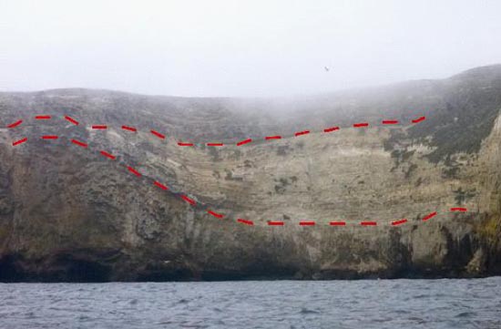
This basic knowledge of the eastern Santa Cruz Island rocks, along with an understanding of the principle of superposition, which states that each successive layer of rock is younger than the rock unit below it, is sufficient to begin critically observing the geology. One location that shows the interaction of all three rock units is a sea cliff north of Potato Harbor. The photograph (Figure 1) was taken looking east. The contacts between the units are highlighted with red dashed lines. A contact between rock units is where the rocks of the two different units touch.
The bottom unit is dark brown and has a rough texture- these are the volcanics. Their position at the bottom indicates the volcanics are the oldest, earliest formed unit. The volcanics curve upwards on the left side. This is likely a result of the lava flowing in a rough, chaotic manner. The white, striped unit above the volcanics is the Monterey Formation. The Monterey Formation is above the volcanics, which means it is younger. Also, the Monterey follows the uneven volcanic surface that curves upwards, signifying the Monterey Formation was deposited soon after the volcanics formed. The contact between these two units is conformable, meaning the volcanics did not have time to erode to a flatter, more even surface before the Monterey Formation was deposited on top. The flat, horizontal unit at the top is the Potato Harbor Formation, which does not follow the curve of the volcanics. This suggests the Monterey Formation had time to erode before the Potato Harbor Formation was deposited, and thus indicates an unconformable contact between the Monterey and Potato Harbor Formations.
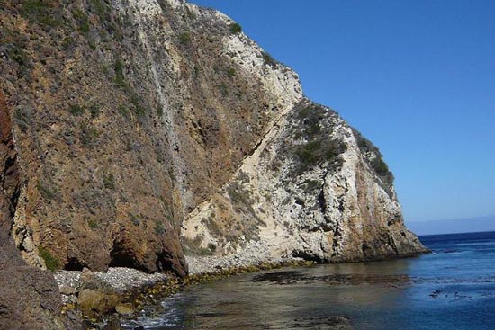
A second interesting cliff exposure can be observed from the dock at Scorpion Anchorage (Figure 2). The dark Santa Cruz Island volcanics are above the white Monterey Formation at this cliff exposure. Here, the volcanics, which were originally located below the Monterey Formation, have been thrust upwards by a fault and are now located above the Monterey Formation.