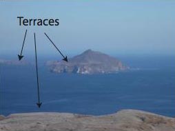
When visiting the northern Channel Islands an astute observer will notice large flat features along the coastlines of the islands. In particular, when viewing Anacapa Island from eastern Santa Cruz Island one can see the broad flat shelf that surrounds the island core (Figure 1). These broad, flat features are marine terraces. Although they are common along the California coastline, it takes a unique combination of geologic processes to form a marine terrace.
First, high wave energy is needed to carve a wave cut platform in to bedrock. A wave cut platform is the broad, gently seaward dipping platform located at the base of the modern sea cliff (Figure 2). Wave cut platforms are the initial step in the formation of marine terraces, but not every wave cut platform becomes a marine terrace.
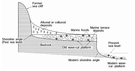
Figure 2: Conceptual model of high-energy coastline morphology. A high-energy wave regime cuts a broad gently seaward dipping platform at the base of the modern sea cliff.
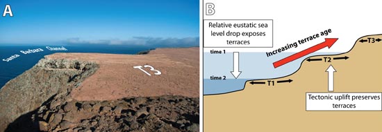
Second, the wave cut platform must be removed from interaction with the high-energy wave regime. This is accomplished by two processes: 1) changing global sea level due to glacial-interglacial cycles, and 2) tectonically rising landmasses. Global sea level fluctuates with the amount of water stored in the polar ice caps. When water is stored in polar ice caps global sea level falls and sea level rises when there is less water stored in the ice caps. Fulfilling our second criterion for terrace formation, the northern Channel Islands are an actively rising landmass, which aids in removing the wave cut platforms from the high energy wave regime. The islands are part of a landmass that is caught beneath the Big Bend in the San Andreas Fault. Tectonic forces are driving the landmass north but cannot due to the presence of the Big Bend. So the landmass is being squeezed which causes the islands to pop-up or actively rise due to the tectonic environment. (See Figure 3 for a model of marine terrace formation.)
Finally, once the wave cut platform is raised above sea level it is removed from subsequent reoccupation from the high energy wave regime and is preserved, usually as a flight of marine terraces along the coastline.
Please see our volume for an in depth discussion of marine terrace formation (Chapter 5) and the tectonic history of the northern Channel Islands, namely Santa Cruz Island (Chapter 2, 3, and 4).