Earth’s Paleozoic, or Era of Ancient Life, spans the time from 541-252 million years ago (Ma). Representing 6% of Earth’s history, sediment, fossil, and geochemical information from Paleozoic rock exposures in the Grand Canyon can give insight into continental scale geologic and hydrologic change from this time period. Understanding these changes can help to interpret the time scale, and magnitude of expected change in sea level, erosion, and environment throughout geologic history, as well as in current earth conditions. The following is a description of these features of the Grand canyon, starting with the oldest, moving to most recent Paleozoic features.
Beginning with the oldest formations, the Cambrian rocks (deposited 525-505 Ma) consist of three distinct Units. The Tapeats Sandstone is the lower unit of the Tonto Group, formed about 525 Ma in the middle Cambrian. Moving eastward its strata become younger, and shift deposition from terrestrial to shallow marine environment. Second is the Bright Angel Shale formation, well exposed along the ‘Bright Angel Trail’, which leaves the popular south rim of Grand canyon National Park, leading all the way down to the Colorado river. Also formed in the middle Cambrian, the presence of shale interlayered with sandstone suggests that it was formed in an open shelf environment during a period of eastward marine transgression, or rising sea levels. The last Cambrian unit is the Muav limestone, formed in the middle-late Cambrian, which consists of limestone, dolomite and calcium rich mudstone, and as it becomes younger eastward, this confirms the eastward sea level rise displayed throughout the Tonto.
Following the Cambrian are the Devonian Units, which although juxtaposed, were deposited 120 million years later. Beginning with the Temple Butte formation, about 385 Ma, this deposit is westward thickening, with its eastern parts forming in paleochannels of the underlying Muav Limestone. However, this juxtaposition implies an unconformity, or age gap of 120 million years based on depositional age. The west edge was likely formed in a subtidal marine shelf.
Two Mississippian Units follow, first the Redwall Limestone, deposited about 340 Ma, colored red by leaching of iron from the overlying Supai Group. This limestone was formed in an inland sea, with common brachiopod, and coral fossils. Its contact with the Temple Butte is missing 40 million years, suggesting uplift and erosion of intermediate units. The second Mississippian Unit is the Surprise Canyon Formation, which is very rich in fossils, which along with the sediment record suggest an estuary environment, that concentrated heavy metals in caves. As a result, the Surprise Canyon Formation is targeted for a variety of mining operations in the region.
Rising further in the Canyon, the Pennsylvanian-Early Permian unit is comprised of the Supai Group, formed 315-285 million years ago. This is a red mud and siltstone, gray limestone that grades into quartz sandstone and repeats. This varying group represents a period of change, where sea level lowered, transforming the region from a depositional to eolian, windblown/terrestrial system and then cycled back to marine and terrestrial environment.
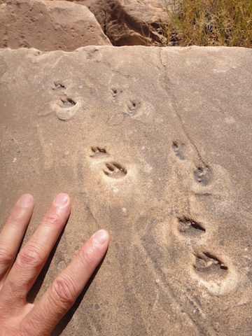
Finally the Permian records the end of the Paleozoic deposition, forming between 280 and 270 Ma. Beginning with the Hermit Formation, which is slope forming, and consists of reddish siltstone, mudstone and fine sandstone, this is interpreted as a fluvial floodplain, with some windblown sand inputs. This is poorly studied in particular because it is poorly outcropped, and lacks fossils. Following the Hermit, is the fascinating Coconino Sandstone, formed 275 Ma, with very low sea levels, the area surrounding the grand canyon may have contained massive sand dunes that are now preserved with sweeping cross stratification. Many fossilized footprints can be found in this unit as seen in the picture below. Just 2 million years later, the Toroweap Formation is deposited under marine conditions of a partially evaporated continental shelf. Last in the Permean is the Kaibab formation, the namesake of many features of the area meaning “Mountain Lying Down”. Formed 270 Ma, this is primarily limestone deposited during the another eastward marine transgression, as it was likely formed in a shallow marine environment.
Continental transformations that supported these environments can be inferred from provenance studies of detrital zircons, which are stable mineral complexes that transport with other sediments. Using detrital zircons, the source of deposited materials can be approximated to a region, helping to track changes in hydrologic flow and topographic change across the continent. The Paleozoic as represented in the Grand Canyon helps understand sea level rise and fall across many millennia, while also tracing tectonic movement, which helps understand how and when present day continents were once connected.