
Why does the Grand Canyon look the way it does? The geologic history of the region contributes to the dramatic scenery of the Grand Canyon. The earth’s surface is made up of a series of large tectonic plates (like pieces of a giant jigsaw puzzle). These plates are in constant motion travelling at a few centimeters per year. The North American plate experienced plate motion, collisions, extension, and uplift during the Phanerozoic Eon. The Panerozoic Eon is the current geologic eon in the geologic time scale, during which abundant animal and plant life has existed. The Panerozoic eon, meaning visible life, began approximately 570 million years ago when diverse hard-shelled animals first appeared.
In the early Panerozoic, North America experienced many changes. From the Cambrian until the late Jurassic period (3-4 hundred million years), the North American plate actually traveled from near the equator, moving to its current position. In the North American plate, land is added by island arcs accreting, plates colliding, land masses combing and then splitting, and also sea levels fluctuating.
During the Late Cambrian to Late Mississippian, (570 to 320 million years ago), the Grand Canyon region remained stable, while thin sheets of shallow marine sediments were deposited.
During the Late Paleozoic to Early Mesozoic (320-200 million years ago), the oceanic plate began to subduct, or move beneath the North American Plate, while Africa collided with the other side of the plate. The stress of the subduction and collision resulted in reactivated faulting and uplift in the Grand Canyon Region. This uplift also produced the Rocky Mountains. The uplift of the Grand Canyon resulted in higher rates of erosion because the increased elevation and exposure made it more vulnerable to the elements.
By the Early Triassic period and much of the Mesozoic period, the Grand Canyon received sediment deposits of volcanic material, as well as other materials that eroded from surrounding highlands of sedimentary and plutonic rocks. This period of sedimentation was followed by the Nevadan and Sevier orogenies (folding by lateral compression to form a mountain range) during the Jurassic and Cretaceous periods. The resulting highlands served as a source of sediments that eroded into the Colorado Plateau. Many Cretaceous fossils are found in the Colorado Plateau, which provides evidence that it was at sea level during this time.
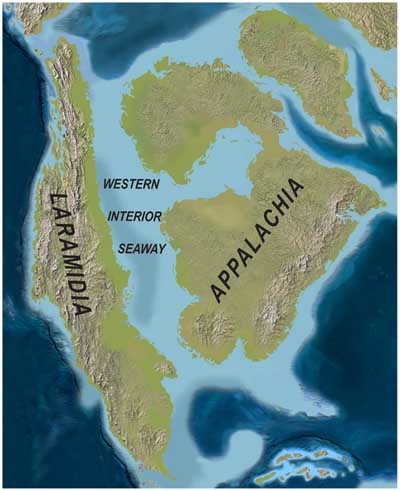
During the late Cretaceous, Early Tertiary, oceanic plate folding beneath the North American Plate and its consequential geometry resulted in a buoyant Laramidia and dragged the center of the North American Plate downward. This event formed the Western Interior Seaway, which separated North America into two land masses called Laramidia and Appalachia (what is currently the West and East coasts). The Western Interior Seaway retreated in the Late Cretaceous.
During the Eocene, the Colorado Plateau was surrounded by mountains that eroded to bury Laramide structures. In the Late Miocene, reactivation of preexisting faults thrust the Colorado Plateau up to 6000 feet above sea level, with a tilt toward the north. The Basin and Range developed in the late Tertiary (Early Miocene). Tectonic extension in this region resulted in dramatic changes in topography.
Finally, during the Pleistocene, the colder, wetter climate sped up erosional processes and allowed the rivers and streams to shape the Grand Canyon’s iconic formations. The structural expressions of these processes can be seen in the Grand Canyon, there’s the Bright Angel Fault, the Kaibab Monocline, which is a large, gentle fold.
The regional changes that accompanied this evolution are reflected in the sedimentary rocks of Grand Canyon. We can think of the layers of sedimentary rock as a stack of pancakes, with the oldest pancake on the bottom. During times when marine settings dominated, the rocks reflect in a shift upward from sandstone and mudstone. When the western plates became more active (Triassic through the present), sandstone and mudstone became dominant. Today, we can see an increase in red color with the upward increase in continental sedimentary rocks in the Grand Canyon.
Why should we care? Going through the Grand Canyon we see the expression of all of these motions and stresses as changes in elevation, erosional surfaces, rock type changes, folds, and faults.